| Never before had I felt so reassured to hear an air-traffic controllers voice on the radio.
The mainland had faded behind us into the mist, and the only visual clue we had was a blue horizon merging from sea into sky. I was flying with my eye trained on the compass heading of 60 degrees North-East. My mind was on the white capped waves 5000ft below us and the all-consuming emptiness.
Out of the mist ahead appeared Fair Isle after what had felt like an eternity, 10 miles away. We could just see the outline, and as we got closer the runway became visible, carved into the island and with ominous-looking cliffs on the east side. The same direction the wind was coming from.
”G-AZ the wind is 080 degrees at 14-18knots.”
Great! A 90 degree cross-wind with cliff rotor thrown in for good measure. The picture ahead was quite dramatic as we rode through the turbulence, lower and lower.
“Hold on, this is going to be bumpy” I advised my very quiet passenger.
“G-AZ, the wind is currently 14knots at 090 degrees”.
As we turned onto the final landing approach at 200ft, it became clear that the runway was made of almost shale and mud in construction; we would have to be very careful not to damage the propeller.
“G-AZ, final, 06”.
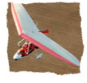
The trike tracked sideways as we slowed and the crosswind took effect. The nose was pointing 30 degrees to the right of our position as we approached at 70MPH. It was all over in what seemed like an instant as I wrestled the trike through the turbulence.
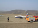
1 hour later we had the wing off once more but de-rigged completely without battens. We folded it up and stored it in the lee of the building housing the fire truck.
Dave Wheeler, our radio support on the way in, also turned out to be the local resident fire-crew, photographer and weather expert all in one; he had been awarded an OBE for his services to Meteorology the year before. Within minutes we sat enjoying home-cooked food at Cath’s B&B on the island. We only had 30 more miles to go before we reached our goal.
We climbed into bed and the lights flickered and faded as the windmill-generated electricity went off at 23:30.
WICK – FAIR ISLE – 15:45 – 16:30
Total Flying: 0:45 mins
DAY SIX
I must admit, I hadn't sleep very well the previous
evening. We had survived one sea crossing and were now off on another.
Sliding the curtains back revealed a blue sky and an island that
was shrouded in a thinly veiled fog. I kept thinking about the runway
surface and it’s potential to damage our propeller on takeoff.We decided to take a walk around the housing area with a total
population of 70, before setting off with our gear to the airstrip.The wind was once again cross-wind, but had dropped to 10 knots.
Dave explained to us how that as the winds were now turning easterly,
the haze might lift and that it would probably not get any worse.The Islander plane arrived as we were assembling the wing and I
wanted to get an airborne perspective on the weather.
"What's the visibility like up there ?" I quizzed.“Ah, I don't know, I only fly at 1000ft and just switch to
IFR when necessary, so I haven’t been near the inversion” he replied.Gulp. Not the answer I wanted to hear, so I called Sumburgh Air
Traffic Control to get a report on their visibility.“We’ve got 7km”.Great! At least it was going to get better further North we went.The windsock danced in varying directions as we warmed the engine
up. By time we were ready to go, the wind had turned to favour the
opposite direction even as we taxiied. We were keen to get off in
the shortest distance possible to avoid prop damage. |
|